There are two directions from which you can approach the site. Via Hope, turning at The old Hall pub, and following Edale Road for 6 miles. Going past Edale car park and the turning up to Edale village,(do not turn up to Edale village) once you have past these, the site is half a mile on, on the right hand site.
Via Mam Tor/ Mam Nick, which is a steep decline into the Vale of Edale. Once at the bottom of the hill the road goes over a bridge crossing the river Noe and the a bend to the right. Follow the road round the bend and on for half a mile the site is on the left hand side just after a barn on the edge of the road.
Nearby Attractions
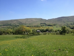
The site is located within a ten minute walk from the station, a twenty minute walk from, the start of the Pennine way, footpaths to Kinder Scout, local pubs, shop and information centre.
Within driving distance of Castleton and its Blue John Caverns.
The towns of Buxton and Bakewell are within 30 minute driving time.
Please mention the UKCampsite.co.uk when you book or enquire!
The facilities shown on this website are a guide only, and you should check with the campsite direct before making any booking. The UKCampsite.co.uk will not be held responsible for any errors or omissions


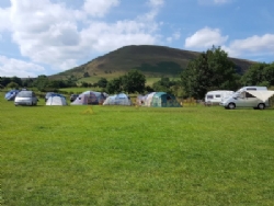

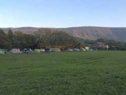
 Tent Pitches
  No Caravans
  Motorhome Pitches
  Small Campervans
  No Glamping Units
  No Statics for Hire
  No Statics for Sale
  No Seasonal Pitches
  No Electric Hookups
  No Hardstandings
  No Fully Serviced Pitches
 Families Welcome
  Not Members Only
  No Rallies
  Not Naturist Site
  Dogs Welcome
  No Dogs Allowed
  Groups Welcome
  Motorbikers Welcome
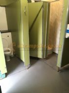
  Toilet Facilities
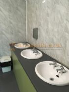
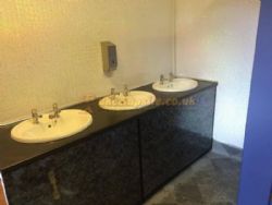
  Hot Showers
  Washing Up
  No Bathroom
  No Baby Changing
  No Laundry
  Drinking Water
  Disabled Friendly
  Chemical Disposal
  No Battery Charging
  No Gas Exchange
  No Recycling Facilities
  No Kitchen Facilities
  No Freezer / Fridge
  No Motorhome Point
  No Wifi Access
  Shop <1 mile
  Bar <1 mile
  Restaurant or Cafe or Takeaway <1 mile
  No Playground
  No TV Room
  No Games Room
  No Evening Ents
  No Fishing
  No Wild Swimming
  No Indoor Pool
  No Outdoor Pool
  No Horse Riding
  No Cycle Hire
  No Golf
  No Tennis
  No Beach
  No Watersports
  No Boat Launch
  No Sea Views
  Working Farm
  No Campfires Allowed
  No Waterside Pitches
  No Dog Walk
  National Trust
 English Heritage
  Fuel Stations
 Good Pub Guide Pubs
